During the course of history, man felt the need to protect his heritage against attackers from the outside world. This need also existed in the Netherlands. The means of defence has generally been in answer to the attacking techniques used and the weapons employed.
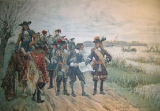 |
| The Oude Hollandse Waterlinie (Old Dutch Waterline, 1672) |
King Willem I gave an order to General Kraijenhoff in 1815 to formulate a plan for the defence of the whole country. Out of this plan arose the New Dutch Waterline. This new line was build East of the Old Dutch Waterline. It was also decided that a Defence Line would be built around Amsterdam. It became a line with simple forts located near the dry areas of the inundations. The earth ramparts and the light artillery made it a weak defence line, however.
|
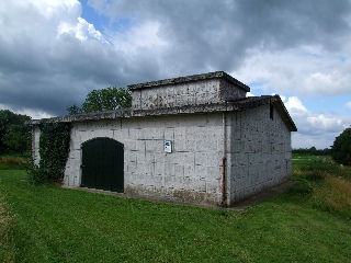
| A remnant of the IJsselline: the bunker, camouflaged as a farm shed, of the Light Anti Aircraft Control Centre (LAACC) near the weir location Olst. (Picture: René Ros, 2007) |
On the April 8th, 1874, the Vestingwet (Fortress Law) was passed. It was required to handle the modernisation of the existing Dutch defences. Many old fortresses were abolished and the defence lines needed updating to face new wartime technical possibilities. Part of the plans included a defence line around Amsterdam as a "last keep", and a line to be defended to the last man.
The last water defence line of the Netherlands was part of the NATO 's defence during the first part of the Cold War. The IJssellinie (IJssel Line) was built between 1949 and 1952 and included the construction of shelters for defence, command and care and the construction of inundation basins in the valley of the IJssel river. The most amazing part of the IJssel Line was the use of three floating weirs, which ensured enough water in the IJssel. Later, the NATO defence line moved into West Germany and in 1964 the line was abolished and finally destroyed. Quite some remains can be found, and the experience gained and the techniques used were later used in the Province of Zeeland for the famous Deltaworks.
")