The general support facilities were often located in Amsterdam, because of the Defence Line and the New Dutch Waterline. Otherwise they played a role during the construction and the use of the Defence Line and made it possible for the forts and soldiers to do their duties.
See Amsterdam Region for more objects outside Amsterdam. |
Storage and Distribution |
|
 Arsenal Arsenal
Originally built as arsenal for Amsterdam Fortress in 1610. Used for the State Printing Office amongst other things. Was used for storage of kitchen and office materials up to at least 1940.
 Show map Show map
|
|
 Grain Silo Korthals Altes Grain Silo Korthals Altes
A private company initiated the building of the grain silo in 1896-1898. This grain silo could store 16,730,000 kilograms of grain and could provide a supply for the civil population during a siege.
The silo has been converted (1999-2000) into apartments.
Show map |
|
 Municipal Bonded Warehouse Municipal Bonded Warehouse
These warehouses contained the main supply of provisions. Located along a harbour at the east side of Amsterdam.
Show map |
|
 Petroleum Harbour Petroleum Harbour
This harbour for receiving and storing light fuel like petroleum was constructed in 1886. It provided a supply of light fuel during a siege.
Show map |
|
 State Clothing Storage Depot State Clothing Storage Depot
Completed in 1877, this building provided clothing and other equipment to the army nationwide. Located in Amsterdam because of its National Keep function.
No longer used as a depot.
Show map |
|
 Storage Depots Conradstraat Storage Depots Conradstraat
Several buildings stood on a terrain along the Conradstraat (Conradstreet) since around 1914. To the West was the Military Bakery.
The Garrison Clothing Storage Depot for the Amsterdam Garrison was built in 1920 but demolished in 1988. Three buildings comprising the Mobilisation Center Amsterdam stood here also.
Two older buildings and the guards house remain.
Show map |
|
 State Medicine Storage Depot State Medicine Storage Depot
Founded in 1795 in The Hague but moved to Amsterdam in 1889. It manufactured, stored and distributed medicines and chemicals for the army, navy, prisons and other state institutions.
No longer used as a depot, as it was converted into offices in 1998.
Show map |
Housing, Feeding and Care |
|
 Amsterdam Cavalry Barrack Amsterdam Cavalry Barrack
Completed in 1865 for housing 202 horses and their riders. It had three levels for the horses, soldiers and hay and straw storage. It was used until after WW II but the horses were replaced by armoured vehicles.
Show map |
|
 National Reserve Office National Reserve Office
Office for the local branch of the volunteer Defence Line of Amsterdam Corps. Founded in 1916 and abolished in 1940. In 1926, 4000 soldiers were members, of which 170 were officers.
Show map |
|
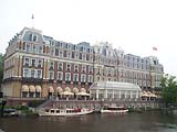 Defence Line Command HQ Defence Line Command HQ
The HQ was situated at several Amsterdam locations of which some are known. The commander had few men under his command and limited authority.
During WW I the famous Amstel Hotel was used as the HQ (pictured left). In 1921 and 1922 the HQ was located in a building at one of the major canals.
Show map |
|
 Military Bakery Military Bakery
The current building was completed in 1928 but an older one previously stood at the same location.
The bakery provided bread to several garrisons both inside and outside Amsterdam. To the West were the Storage Depots Conradstraat.
It was decommissioned after 1950 and was eventually converted into apartments.
Show map |
|
 Military Baiting-place Military Baiting-place
It was the responsibility of the municipality of Amsterdam to provide food and shelter for the military personnel in the city. A baiting-place was provided for the officers. This was mainly used by the returning officers from the Dutch East-Indies (now Indonesia).
Show map |
|
 Militia Building Militia Building
Originally built as arsenal for Amsterdam Fortress. Building used for the army conscriptees administration.
Show map |
|
 Orange Nassau Barrack Orange Nassau Barrack
Originally built for the French army of Napoleon, but completed in 1814 when King William I reigned. It housed the 7th Infantry Garrison and the 1st and parts of the 2nd Artillery Garrison until 1922. It was used by the army until 1989.
It has since been converted to apartments and business units.
Show map |
|
 State Military Hospital State Military Hospital
This army hospital provided care to a maximum of 300 patients in peace and war. It was built in 1870 but decommissioned around 1920. From 1929 to 1979, it was still being used as a hospital for the Nederlands Kanker Instituut (Dutch Cancer Institute).
Show map |
|
 State Carrier Pigeon Station State Carrier Pigeon Station
Built before 1850, it was bought in 1863 by the Artis Zoo for housing wolves, bears and other such animals. The upper floor was on loan by the Ministry of War for the State Carrier Pigeon Station from 1894 until after WW I.
The building still being used as part of the zoo.
Show map |
Production and Maintenance |
| |
 Rainwaterbassin Rijksmuseum Rainwaterbassin Rijksmuseum
The basement of a later added, separate building of the Rijksmuseum, were three rainwaterbassins for collecting and storing rainwater for use as drinking water. These bassins are still present.
Show map |
|
 Rainwaterbassin Justice Palace Rainwaterbassin Justice Palace
On the two inner courts of the Justice Palace were two rainwaterbassins built in 1892.
In 1931 both bassins were converted for storage by raising the walls. The bassins were again converted for the heating equipment (1954) and restaurant (2003).
Show map |
Airforce and Navy |
|
 Naval Station Kattenburg Naval Station Kattenburg
A shipyard for the United East-Indies Company since 1655, this was later used as a military shipyard and docks. It was also a supply station for which warehouses were built e.g. the "Large Seawarehouse" from 1791 (pictured left).
The last big ship was built here in 1908. The shipyard was closed in 1915, thereafter used for storage, education and research facilities for the Royal Dutch Navy. The "Large Seawarehouse" now houses the Dutch Maritime Museum.
Show map |
|
 Naval Airforce Station Schellingwoude Naval Airforce Station Schellingwoude
This was used by water planes since 1916 until after WW II. It was mostly used as an independent station but after 1939 as a backup. It had initially one, later two, hangars and slips. It was located on the artificial island Zeeburg.
It has been completely dismantled but the last slip wasn't demolished until after 1986.
Show map |
Terrains |
|
 Entos Area Entos Area
Probably between 1914 and 1918, at least in 1916, about three wooden barracks were located here. They provided housing for reserve troops. The area was used in 1913 for the First Dutch Exhibition on Shipping (which abbreviates to "ENTOS" in Dutch). It lies close to the railway station Amsterdam Central.
Show map |
|
 Zeeburg Zeeburg
Zeeburg, previously a slush depot, is now an artificial island. Rifle ranges were located here in WW I and since 1916 a Naval Airforce Station was located at the north side of the island. During and after WW II, barracks for housing soldiers were also located on the island.
Currently used for different civilian purposes and is a major traffic area because of the many bridges and tunnels.
Show map |
|
|
|

")
")